I received this email today:
Welcome to a special edition of Missouri State Park eFriends. We wanted to take this opportunity to update you on the status of Johnson's Shut-Ins State Park.
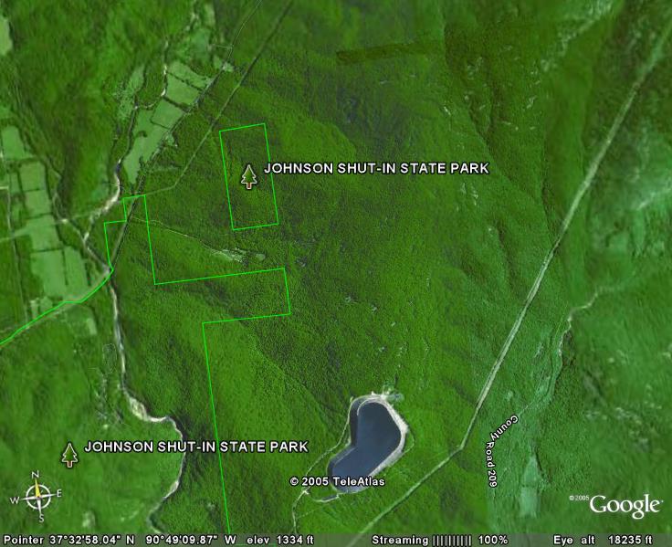
On Dec. 14, the Taum Sauk Reservoir near Lesterville failed, sending more than one billion gallons of water into Johnson's Shut-Ins State Park. The flooding caused extensive damage to the area of the park along the East Fork of the Black River where most of the park's facilities are.
Facilities receiving extensive damage include the campground, the water and wastewater systems, the boardwalk along the shut-ins and the superintendent's residence. Other structures received damage as well, including the park store and office. Mud and debris cover much of the area, including within the shut-ins area itself. A portion of the Taum Sauk Section of the Ozark Trail between Johnson's Shut-Ins State Park and Taum Sauk Mountain State Park was damaged and is closed.
The Department of Natural Resources, working with other agencies, has begun an evaluation of the damage to the park's cultural and natural resources as well as its structures. Once any immediate environmental issues are addressed, we will begin to determine the best method of cleanup and recovery.
Park superintendent Jerry Toops and his family lost their home when the flood occurred and his three young children were hospitalized. The two younger children have been released from the hospital but the oldest one, who is five years old, remains hospitalized. Several donation accounts have been set up to assist the Toops family, who lost everything in the
flood.
Johnson's Shut-Ins State Park remains closed until further notice but we are committed to rebuilding and reopening the park. It is too soon to determine when this might be.
The Goggins Mountain hiking and equestrian trail and trailhead, which is located in a different area of the park, remains open. All other state parks and historic sites in the area were undamaged and remain open.
For more information about the park and the recovery effort, please visit the Web site at www.mostateparks.com. The Web site includes before and after photos of the park, and updated information on the situation. This Web site will be updated on a regular basis to keep everyone informed of the progress.
Thank you for your continued support of the state park system. I will continue to send you updates on the progress at the park through eFriends and you can always receive more information through our Web site.
Doug Eiken, Director
Missouri Department of Natural Resources
Division of State Parks
Thursday, December 22, 2005
Friday, December 16, 2005
Pictures of the Taum Sauk Reservoir damage
Pictures have been posted on the Missouri State Park's Johnson's Shut-Ins website of the severe damage as well as before and after shots.
Many dramatic pictures and video as well as the reservoir history can be seen on the St. Louis KSDK website. An earlier story with more pictures and video can be found here.
A 600 ft section of the reservoir gives way releasing over a billion gallons of water.
Many dramatic pictures and video as well as the reservoir history can be seen on the St. Louis KSDK website. An earlier story with more pictures and video can be found here.

A 600 ft section of the reservoir gives way releasing over a billion gallons of water.

The water stripped the side of Profitt Mountain of trees and soil.
The water then rushed through Johnson Shut-ins and on down the Black River valley destroying a home, damaging trees and sweeping vehicles off the roads.
Wednesday, December 14, 2005
prior to Taum Sauk Reservoir failing (cracks and all)
 Visitors on top of the Taum Sauk Reservoir
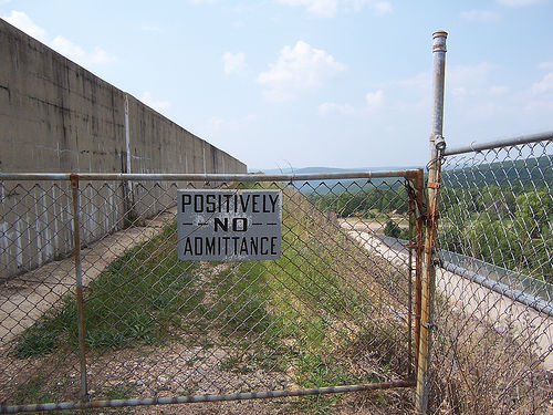 High security!
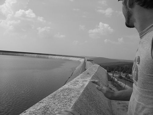 A view across the reservoir
Taum Sauk Reservoir breaks and floods Johnson Shut-ins
A breaking news report: the reservoir above Johnson Shut-ins has broken and washed out the park. There isn't much info yet... I'll update here when I get more.
Information regarding the reservoir can be found here and at this point is all over the news and other blogs.
Here's a good report of the damage and injuries. I'm still searching for any pictures of the are post accident.
Wednesday, November 30, 2005
Forest Service releases Mark Twain management plan
11/23/2005
ALAN SCHER ZAGIER
Associated Press
COLUMBIA, Mo. - Visitors to the Mark Twain National Forest can expect more intentional fires, a greater emphasis on habitat restoration and largely unchanged limits on timber harvesting under a new management plan released Wednesday.
The revised plan seeks to strike a balance between economic interests and environmental protection, said Randy Moore, a regional supervisor with the U.S. Forest Service. The federal agency manages the 1.5-million acre forest, which sprawls across parts of 29 counties throughout southern Missouri.
"The Mark Twain National Forest is uniquely positioned to provide abundant multiple uses while conserving the ecology and culture of the Missouri Ozarks," Moore wrote in a report outlining the new plan.
Federal scientists and regulators looking to update the forest's current plan, adopted in 1986, considered five alternatives. The options ranged from a ban on commercial timber harvests to retaining the status quo.
As expected, the Forest Service adopted a plan it called "Alternative 3."
That option will classify 29 percent of the forest as habitat worthy of restoration to its natural state while doubling the number of acres burned over the next decade - a technique also used to promote habitat restoration.
Timber industry lobbyists objected to the increase in prescribed burning, a practice first used by American Indians centuries ago to improve their access to food and shelter.
"This is not the natural forest," said Jerry Presley, a consultant to the Missouri Forest Products Association and former director of the state Department of Conservation. "It is a condition they have arbitrarily decided to create."
Environmental groups, in turn, said they are disappointed the Forest Service didn't appreciably change the limits on timber harvesting.
The new standard is 103 million board feet of wood per year; the current limit is 105 million board feet annually, though harvests from the past several years have produced only about half that amount.
"The Forest Service puts it forward as a compromise of interests, but I think that's a real dodge from the issues," said Jim Scheff of the St. Louis-based Missouri Forest Alliance. "That's not how the public wants its national forests managed."
Presley, though, noted that several federal laws authorize timber sales in national forests, a practice he said also promotes ecological diversity.
"Timber management is good for wildlife purposes," he said. "It creates (favorable) conditions for certain kinds of species. If you just let the forest grow naturally, you're going to lose some of those amenities."
Forest activist Jim Bensman of Heartwood Forestwatch, which has sued the federal agency numerous times for what it calls a lax regulatory stance, said his group is already working on an administrative appeal of the Mark Twain decision - a precursor to a lawsuit.
"It probably will be an exercise in futility," he said.
The revised plan also extends areas of the forest where livestock grazing is prohibited and suggests 13 areas for consideration as designated wilderness areas.
One topic it does not address in detail is the use of off-road vehicles in the forest. A separate environmental analysis of a proposal to temporarily expand off-road access in designated areas of the Mark Twain forest will be released early next year, said Ronnie Raum, the forest's Rolla-based supervisor.
The complete management plan can be found on the Web at http://www.fs.fed.us/r9/forests/marktwain.
Tuesday, September 13, 2005
Ozark Trail Service: Sept 25-Oct 1
The American Hiking Society has another Volunteer Vacation sponsored by the Ozark Trail Association. Work will be on the Middle Fork section of the Ozark Trail. The much anticipated completion of this section will open up 200 miles of continuous trail through Missouri. Volunteers will tent camp at the Council Bluff Recreation Area 20 miles southwest of Potosi, Missouri. The crew will drive to the work site each morning. The hike in will be one-half mile or less. Food is provided. The cost is $120 ($95 for members of the AHS). Additional work events can be found on the official OT website.
Friday, September 09, 2005
John Roth to speak to hikers

According to the Hot Springs Village Voice, John Roth, President of the Ozark Trail Association, will be the speaker at the Oachita Mountain Hikers evening meeting to be held September 15th at 6:00 PM at the Garland County Public Library. To learn more about the hikers, check out their web page. John Roth who has coordinated Ozark Trail maintenance for several years has been mentioned before on this blog and has his own blog here.
Monday, August 15, 2005
A jaunt up Missouri's top mountain
PETE GRATHOFF
Associated Press
ARCADIA, Mo. - At long last, the peak is in sight.
It has been more than seven hours since we set out, and my hiking companion is panting like a dog. Earlier, I had to carry her as we worked toward the summit.
But now, we walk together and reach the top of Taum Sauk Mountain, the highest point in Missouri. My hiking companion is Molly, a 3-month-old shepherd-Lab mix. Her tongue hangs out of her mouth, and she gazes up at me as I declare, "We're standing on top of Missouri!"
The Kansas City Star's Outdoors editor, Brent Frazee, said the time had come for a hiking story, one that would require a great deal of physical exertion.
He suggested I go.
This actually is the kind of assignment I love, because the rougher the trail, the farther away it is from civilization. The stuff I had read on the Taum Sauk section of the Ozark Trail sold me, particularly the 13-mile stretch from Johnson's Shut-Ins to the high point of Missouri: Taum Sauk Mountain.
It is preferred by those who routinely hike the Ozark Trail.
"It's probably my favorite section of the trail, because of the scenery and the water features and the rock formations," said Steve Coates, president of the Ozark Trail Association. "The views from the top of those hills are what's most impressive to me."
For some, the trouble with the views is you can't enjoy them without first undertaking a healthy climb. It's easy to scoff at the notion of scaling a mountain in Missouri, whose highest peak at 1,772 feet ranks 41st in the nation. By comparison, California's Mount Whitney is the highest point in the continental United States at 14,494 feet.
OK, so you won't need oxygen tanks. But the hike from Johnson's Shut-Ins crosses Proffit and Taum Sauk mountains and has climbs of roughly 2,000 feet and a descent of nearly 1,000 feet before all is said and done.
"It can be a pretty grueling hike with the footing the way it is. It can be tough," Coates said. "Then as you hike across those glades, they're very open and exposed, and the rocks tend to heat up. Those rocks can be 10 degrees warmer than it is around and really get pretty hot."
But not as hot as they once were.
"That's all remnant igneous rock right there," Coates said. "Those are the St. Francis Mountains, and those are old, old remnant volcanoes, so there is a form of granite down there that's called dolomite. It's kind of an iron-based rock that gives it its reddish color, and you see a lot of that down there, and some of the habitat is rather unique. I just love it."
On this particular summer day, there wasn't anything too out of the ordinary to see in terms of the wildlife: deer, turkeys and skinks. But there were a fair amount of black-eyed Susans, and the landscape is the best part of this hike.
The Black River runs close to the trail in parts, and you must cross it at one point just before it feeds into the Johnson's Shut-Ins. The water flows among the huge, smooth rocks, creating natural water slides..
How the Shut-Ins were formed is quite a story.
According to the Department of Natural Resources, it all began more than a billion years ago when hot volcanic ash and gases spewed into the air, cooled, and formed igneous rock. Later, shallow seas covered the rock, depositing sedimentary rock. The land rose. The sea fell. The weather began tearing down the land, exposing the volcanic rock beneath it.
Waters of the Black River became confined, or 'shut in,' to a narrow channel. Waterborne sand and gravel cut deeply into the erosion-resistant rock, carving potholes, chutes and spectacular canyonlike gorges.
Yet that means little when a sweaty hiker reaches the Shut-Ins.
"It's a lot of fun to climb around on those rocks and kind of lay in those pools and let the water splash over you," Coates said. "It's really refreshing."
It should be noted that dogs are not allowed at the Shut-Ins, so our hiking party did not partake in that pleasure.
The Shut-Ins aren't the only natural wonder on the hike. Perhaps just as well known is the Mina Sauk Falls, the highest waterfall in Missouri.
Mina Sauk was named for the daughter of Piankashaw Indian chief Taum Sauk. According to the Missouri Department of Conservation, legend has it the falls were formed when Mina threw herself off the mountain after her people had killed her Osage lover in a similar manner. The Great Spirit sent a bolt of lightning, which split the mountaintop, and water flowed over the ledges, washing away the blood of the lovers.
In the spring, blood-red flowers called Indian pinks grow along the banks of the stream.
Mina Sauk Falls drops 132 feet over three rocky outcrops. On our hike, however, it was bone dry because of a recent drought.
Less than two miles from Mina Sauk Falls is yet another interesting geological formation: the Devil's Tollgate, an 8-foot-wide passage through volcanic rock standing 30 feet high.
"That was an old road basically," Coates said. "Actually, I've been told it's an old Civil War road, too. That was a spot where the trail is kind of wide right through there, and it's the old roadbed. It's a good marker to say, 'Meet us at the Devil's Tollgate,' and historically, I'm sure a lot of events have taken place there through the course of time. It's a really, really neat place."
Supposedly, Jesse James hid out at Taum Sauk, so who knows, maybe there's some little-known history to the area as well.
But it's doubtful that he knew Taum Sauk would one day be considered a gem for hikers, a place that draws people for the quiet, the challenging climbs and the view.
Molly and I were impressed, even if she pooped out. Perhaps it wasn't wise to take such a young pup, because the hike is not to be taken lightly.
"It's very rugged, a lot of rocky footing and a lot of open glades," Coates said. "But especially in early spring ... you can see some really neat vistas."
Sunday, May 01, 2005
Palmer advocacy
Dale Hallett has written a couple of articles on the protection of Palmer an old mining town located in the Mark Twain Nation Forest. His article Forest Service ORV Study slams the Forest Service's idea of opening land to ATVs and argues safety and additional stress on an already taxed local fire department. Make sure you check out the links at the bottom to Take a Ride Through An Offroad Park and See What They Intend To Do To Palmer
and Hell on Wheels. Maps of the proposed study areas can be found here. In Dale's next article Environmental Impact Statement Due he discusses inadequate enforcement but also gives the side of the Forest Service. Dale was also published in The Journal with a similar article.
Good reads!
and Hell on Wheels. Maps of the proposed study areas can be found here. In Dale's next article Environmental Impact Statement Due he discusses inadequate enforcement but also gives the side of the Forest Service. Dale was also published in The Journal with a similar article.
Good reads!
Wednesday, April 27, 2005
Yes, it's still FREE!
A nice article was published in the Kansas City infoZine entitled Experience Southeast Missouri on a Weekend Trip to Missouri State Parks and Historic Sites. There isn't much here on hiking or the Ozark Trail but I think it's great they drove the price home. Free free free free!
Tuesday, March 01, 2005
Old news but informative...
An archived KOMU story from 2004 by Brock Spencer: More ATV Trails:
The Environmental Impact:
The plan to open new ATV trails in Mark Twain National Forest, also opened the dispute between the U.S. Forest Service and environmental groups.
The Forest Service wants to open trails in Missouri at the Potosi District near Palmer, at the Cherokee Pass near Fredericktown and at the Popular Bluff District near Williamsville. The trails would allow the Forest Service to study the environmental impact of ATV’s in the forest.
Environmental groups disagree with adding new trails and the way the Forest Service plans to study it. They argue that ATV’s cause a significant amount of damage and the study would violate the National Environmental Policy Act (NEPA).
The Forest Service plans don’t include studying four-wheeler use at the Cedar Creek District near Ashland. Carol Trokey, Cedar Creek Forester, explains her district would not make sense for ATV use because it is small land base with scattered ownership. The District owns 16,500 acres, but a lot of areas are fenced because of private ownership and the soil doesn’t have a lot of rock to withstand off-road vehicle use.
The addition of new trails resurfaced a year ago when Dennis Sparks, founder of the South Eastern Missouri ATV club (SEMO), walked into the Poplar Bluff District office of Mark Twain National Forest, and asked why can’t we drive ATV’s in the District?
Henry Hickerson, the Poplar Bluff Ranger, said, “ he couldn’t give him a good sound reason.”
Charlotte Wiggins, Mark Twain National Forest Spokeswoman, said the Forest Service began working with ATV groups like SEMO and JEEP Thing Club over the summer to “develop and embrace current historic use areas like the Potosi District.” The JEEP Thing Club helped map trails near Palmer with global positioning satellite tools.
While the Forest Service worked with ATV groups, environmental groups like the Sierra Club and the Missouri Coalition for the Environment felt they were kept in the dark.
Sierra Club Director Ken Midkiff: finds the situation “nothing but a backroom deal.” His group advocates against the creation or use of any ATV trails in Mark Twain Forest.
The Sierra Club says four-wheelers tear up the forest, cause erosion, and destroy habitats.
Ted Heisel, executive director of the Missouri Coalition for the Environment, says he was surprised at how hard it was and how long it took for him to hear about the new study.
The Forest Service plans to open old mining and homestead trails in the Potosi and Poplar Bluff Districts that won’t cause any new impact to the forest because the trails were established many years ago.
Midkiff says the Sierra Club plan to seek litigation, if the Forest Service doesn’t create an environmental impact statement.
The Forest Service expects to release trail maps in December and January to get public comment.
Saturday, February 26, 2005
Multi-Use Trails
There is a place for all recreationalists and I believe Missouri has a need for multi-use trail. When I moved back here I had a big problem with the multi-use trail systems. I wanted everything to be Appalachian Trail purist foot traffic only. I never wanted to see a biker or a pile of manure. I still never want to see an ORV.
In the Midwest, there are not enough hikers and there is not that much demand for a hiker only kind of trail. I also don't think there is the kind of protection effort there is in the East. I could be wrong in this but these are my opinions. Missouri doesn't have the dense human populations like the East coast. Our wilderness areas are remote. When you hike, multi-use trail or not, you will very likely be the only person on the trail. If it is solitude you want, our trails offer it. So shouldn't there be plenty of room for different trail uses?
In a way sharing use of our trails help increase their maintenance. To employ larger groups of voluntarism, biker clubs, equestrian groups, and hiking organizations are all maintainers. For those areas that need additional protection, we have a few foot traffic only zones. I suppose if there are foot-only purists, the Midwest can offer that too.
As I mentioned before, when I moved back here I had difficulty adjusting to multi-use trails. I have not converted totally. I have had encounters with speeding cycles. I still hate meeting a pile of manure in the middle of the trail. The summer time humidity is enough to deal with without having to be choked by the equestrian stench. The mud holes a horse makes are many times impassable without getting mud up to your knees. I'm not a biker but when those mud holes dry, they are hard enough to walk over--I can only guess the beating they would be on a bike. Out of the three, hiking, biking and horses, I would do away with the equestrian use. They are by far the most damaging.
ORV use is not allowed in many public areas. Of course all of the federally designated wilderness areas ban motorized vehicles. However, they are still a huge issue. As remote as some of the areas are around the Midwest and without adequate policing it is very difficult to stop illegal access. It is incredible the amount of destruction that ATVs can cause in a very short period of time. This an interesting time here in Missouri. As discussed here before, the Mark Twain National Forest just released their new plan for the next 15-20 years and it is currently open for public comment. The Ozark Trail Association has their own reaction to the plan. John Roth is fundamental behind these opinions and has recently opened a blog on the topic with ORV abuse as his first comment. It's an eye opening and sad read.
ORV abuse is a problem all over. During my time as an AT overseer, I had a continual struggle to keep illegal side trails closed along my Maryland stretch. I have no doubt they are wide open today, it only took them a few weeks to clear them every time I made an effort to shut them down. Walking this same area with a trail maintenance crew an ATVer was driving down the middle of the AT. Even federally protected trails have a problem.
In Missouri...
In Missouri we have created refuges for animals, to protect them from man. Now we need refuges for man, to protect him from the machines he created.
-Dan Saults
-Dan Saults
Monday, February 07, 2005
Sunday, January 30, 2005
Feral Hogs Destroying Missouri Public Lands
An article in the All American Patriots and also on the Missouri Department of Conservation's website describes the growing challenge of Missouri Public Land Managers to control feral hog populations. These wild hogs can carry diseases, destroy crops and devastate ecological areas. Ecological damage includes: native plants and wildlife by rooting up roots and eating anything they can catch, including quail and turkey nests and young mammals, including deer fawns. Indirect damage includes competition for food, such as acorns, and erosion that takes place after hogs root up large tracts of ground. Feral hogs seek out springs, seeps and fens destroying ground cover and contaminating streams with their feces.
Weighing in between 100 and 500 pounds, these piggies are not easily intimidated and the article states that several hunters have been treed by hogs. While I haven't heard of any hikers being chased by wild hogs I have heard hiker reports of individual and groups of feral hogs around Taum Sauk and Johnson's Shut-Ins. The Missouri Conservation Department has seen signs of hogs at popular areas as Lake Wappapello, Pomme De Terre Lake, Fort Leonard Wood, Johnson's Shut-Ins State Park, Table Rock Lake and recently, north of the Missouri River. The Missouri Conservation Department has more information about these hog populations here. If you do see feral hogs or signs of them you are urged to contact wildlife officials at (573) 449-3033 ext. 13.
Weighing in between 100 and 500 pounds, these piggies are not easily intimidated and the article states that several hunters have been treed by hogs. While I haven't heard of any hikers being chased by wild hogs I have heard hiker reports of individual and groups of feral hogs around Taum Sauk and Johnson's Shut-Ins. The Missouri Conservation Department has seen signs of hogs at popular areas as Lake Wappapello, Pomme De Terre Lake, Fort Leonard Wood, Johnson's Shut-Ins State Park, Table Rock Lake and recently, north of the Missouri River. The Missouri Conservation Department has more information about these hog populations here. If you do see feral hogs or signs of them you are urged to contact wildlife officials at (573) 449-3033 ext. 13.
Saturday, January 29, 2005
2005 OT Trail Map!
A new color trail map of the Ozark Trail is now available. To request copies of the 10 x 15 inch map brochure write to or stop by the USFS in Rolla.
Mark Twain National Forest
401 Fairgrounds Road
Rolla, MO 65401
(573) 364-4621
Mark Twain National Forest
401 Fairgrounds Road
Rolla, MO 65401
(573) 364-4621
Mark Twain Forest Plan (revised)
A new plan was released 1/27/2005 by the Forest Service that will be used as a guide for the next 10-15 years. The Forest Plan list 5 alternatives, the best "allows National Forest managers to work with nature to conserve important plant and animal species, create and maintain healthy ecosystems, and provide a variety of products that local communities and the nation as a whole consider important. Among these products are recreation opportunities, timber products and clean water and air."
Stay tuned on how these changes to the Mark Twain National Forests will affect the Ozark Trail.
Stay tuned on how these changes to the Mark Twain National Forests will affect the Ozark Trail.
Saturday, January 15, 2005
Online OT Resources
Here is a collection of links with OT and other trail reviews, journals and pictures:
Danny's Missouri Backpacking & Hiking Trails Review
Ozark Backpacking
The McKeel's Ozark Trail Information
Rich Bauer's Trips
Dale Garrison's Gallery
Danny's Missouri Backpacking & Hiking Trails Review
Ozark Backpacking
The McKeel's Ozark Trail Information
Rich Bauer's Trips
Dale Garrison's Gallery
Monday, January 10, 2005
The Palmer Ghost
Hiking near the Courtois section of the Ozark Trail? Watch out for "The Palmer Ghost!" Quietly resting in the woods not far from the trail are a few grave markers including Rose Wingo who died March 16, 1872 at the age of 14 years of fever. This small slave cemetery also known as The Wingo Cemetery is just outside of what use to be Palmer, Missouri, now part of the Mark Twain National Forest and deep in Civil War history. The Palmer Ghost is said to belong to a woman who died in 1850.

If you are brave enough here is how to get to the few remaining stones according to Robert Smith:
Head north from Hazel Creek campground. There is an unnamed creek that feeds into Snapps Branch. As the trail takes a right turn to cross this tributary, there are two ORV trails going left, leading up the same hill that you just came down. Take either of these trails up the hill approximately 1/8 mile. The gravestone would be very hard to find, but the tacky plastic flowers around it is a dead giveaway (pun intended). I didn't notice any other gravestones, but I wasn't looking for any.
Head north from Hazel Creek campground. There is an unnamed creek that feeds into Snapps Branch. As the trail takes a right turn to cross this tributary, there are two ORV trails going left, leading up the same hill that you just came down. Take either of these trails up the hill approximately 1/8 mile. The gravestone would be very hard to find, but the tacky plastic flowers around it is a dead giveaway (pun intended). I didn't notice any other gravestones, but I wasn't looking for any.
A stream...

Sunday, January 09, 2005
Ozark Trail receives grants
This came across Google News on 12/28/04 - The South Missourian News - Ozark Trail Receives Grant. However I think this is the same money given by the Recreational Trails Program in this press release and shared by three counties. Either way several notable OT projects were allocated money through this funding. The Rock Hollow Trail which will eventually become part of the OT also recently landed a grant.
Backpacker magazine
There was a nice article on the Ridge Runner Trail in Backpacker magazine. Other nice articles in the past have included Buford Mountain and the Hercules Glades. I find it odd that not much attention has been given to the Ozark Trail. Actually, not much attention is given to the Midwest at all. A few weeks ago I picked up the current issue (February) and it was titled "Midwest Hiking Edition." Umm, where in that issue do they talk about ANY Midwestern trail?
The Ozark Trail
With almost 400 miles of completed trail in Missouri, the Ozark Trail very easily holds my interest. A few years ago, I lived in Maryland and very quickly became involved with the Potomac Appalachian Trail Club. I've always enjoyed hiking but the idea fascinated me of starting a walk on a trail in Georgia and not having to stop until you reach Maine. I began researching the Appalachian Trail. I read a couple of books, got involved with trail maintenance, and took a few hikes. I was hooked. Now I call Missouri home and I find the same kind of fascination in the Ozark Trail. Although in its infancy, the OT has the same rising support that the AT once endured.
Welcome to Showme Hiking
This blog is dedicated to collecting news, resources and history surrounding hiking areas in Missouri. I will concentrate on the Ozark Trail but will add information about other hiking locations in the midwest as I find interest (such as the Ozark Highlands Trail and the Buffalo River Trail).
 From the Ozark Trail Association's website:
The Ozark Trail is a part of 25 year-old vision to build a scenic and varied route through the Missouri Ozarks, stretching from the St. Louis metropolitan area southwestward to the Arkansas border, eventually connecting to the Ozark Highlands trail-- creating a 700 mile through-trail. Almost 550 miles of trail have been completed, with 350 miles in Missouri.
The Ozark Trail is a part of 25 year-old vision to build a scenic and varied route through the Missouri Ozarks, stretching from the St. Louis metropolitan area southwestward to the Arkansas border, eventually connecting to the Ozark Highlands trail-- creating a 700 mile through-trail. Almost 550 miles of trail have been completed, with 350 miles in Missouri.
Subscribe to:
Posts (Atom)